
St. Marks River to Lighthouse
St Marks River Park, River Breeze Street, Saint Marks, FL, USA
http://fdep.maps.arcgis.com/apps/MapTour/index.html?appid=14d62d9e275e48e49c72f6880cab9acf
Add To Trip Planner Directions
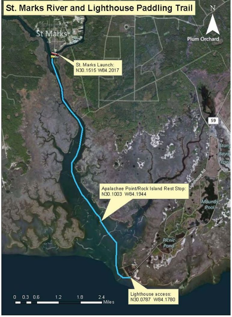
Overview: Begin at the St. Marks Boat Ramp. Paddle downstream following the left (east) bank, passing limestone rock islands and continuous stands of marsh grass bordering the St. Marks National Wildlife Refuge. Stop for lunch or a break at Apalachee Point/Rock Island. Upon entering Apalachee Bay, follow the shoreline to the St. Marks Lighthouse. Take out at the St. Marks Lighthouse parking lot.
Considerations: Take this trip on an outgoing tide. The water in the Bay is shallow, but can be choppy in windy conditions.
Focus: Fishing and photography.
Distance: 6 miles, 3 hours. It is 4.1 miles to the entrance of Apalachee Bay
Put In: St. Marks Riverfront Park and Launch. From US Highway 98, turn south at the intersection with Port Leon Dr. (SR 363) toward the City of St. Marks. Follow signs to San Marcos de Apalache Historical State Park, which is adjacent to the launch, with restrooms, pavilions, trash cans, and parking. Put in at the grassy area next to the boat ramp.
Take Out: St. Marks Lighthouse parking lot. Continue east on US Highway 98, passing the community of Newport, and crossing the St. Marks River. Turn south (right) onto CR 59 (Lighthouse Drive) and continue through the St. Marks National Wildlife Refuge to the lighthouse at the end of the road. At high tide, take out here or at low tide at the boat ramp accessed by the waterway west of the lighthouse.
Expertise: Intermediate and up.
Click here for trail map and guide.
DISCLAIMER: The Original Florida Tourism Task Force (dba Visit Natural North Florida) and the North Central Florida Regional Planning Council do not warrant the accuracy or timeliness of this map and paddle guide or the safety of this trail for use by paddlers. Paddlers should use this trail only if they have the adequate skill level and equipment, and paddlers must make that determination. Paddlers should also check weather forecasts and water levels in advance to avoid unnecessary danger. The Original Florida Tourism Task Force, the local governments in which this paddling trail is located and the North Central Florida Regional Planning Council are not responsible for any damages whatsoever from its use.