
Chaires Creek
Ochlockonee Bay Boat Ramp, Coastal Highway, Panacea, FL, USA
dep.maps.arcgis.com/apps/MapTour/index.html?appid=10bf2899ff37461d932f3e1ff8de9fa4
Add To Trip Planner Directions
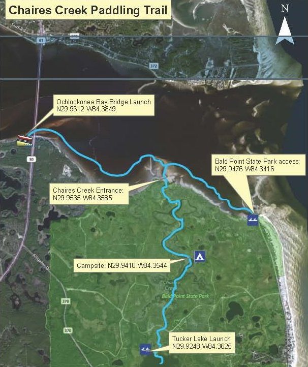
Overview: Begin at the Ochlockonee Bay Boat Ramp in Franklin County, located at the south end of the Ochlockonee Bay Bridge. Paddle east along the Bald Point State Park shoreline for 1.7 miles to Chaires Creek. Travel 2 miles up Chaires Creek to reach Tucker Lake. Take out at the landing located on northwest side of Tucker Lake. Or launch from Bald Point State Park.
Considerations: Enter Chaires Creek on high tide. This is a sheltered trip, in shallow water.
Focus: Explore the extensive tidal creek system. Fishing in the lake and creek can be excellent. Sea Trout, Red Fish, Flounder, and Sheepshead are common catches. This is also an excellent area to cast a net for Mullet or catch Blue Crabs.
Distance: 3.7 miles, 2 hours.
Put In: Ochlockonee Bay Boat Ramp at the south end of the Ochlockonee Bay Bridge. Or launch from Bald Point State Park on rising tide. Both have sandy launch, parking, dock, beach, toilets, and benches.
Take Out: Tucker Lake launch in Bald Point State Park. Take US 98 south over the Ochlockonee Bay Bridge. Turn east (left) onto CR 370 for 3/4 mile to the Ranger Road on the left. This paved drive provides access to a fishing bridge over Chaires Creek and the kayak launch on Tucker Lake. Has natural dirt entry, signs, parking, benches, toilets, trash cans.
Expertise: Intermediate and up. Beginners can launch and paddle around the protected waters of Tucker Lake.
The following map and trail guide are provided courtesy of Florida Department of Environmental Protection, Florida Coastal Management Program, the Wakulla County Tourist Development Council and the Florida Department of Economic Opportunity.
Click here for trail map and guide.
Disclaimer: The Original Florida Tourism Task Force (dba VisitNatural Nroth Florida) and the North Central Florida Regional Planning Council do not warrant the accuracy or timeliness of this map and paddle guide or the safety of this trail for use by paddlers. Paddlers should use this trail only if they have the adequate skill level and dquipment, and paddlers must make that determination. Paddlers should also check weather forecases and wter levels in advance to avoid any unnecessary danger. The Original Florida Tourism Task Force, the local governments in which this paddling trail is located and the North Central Florida Regional Planning Council are not responsible for any damages whatsoever from its use.