
Spring Creek Inside Passage
Bottoms Road Boat Landing, Bottoms Road, Panacea, FL, USA
http://fdep.maps.arcgis.com/apps/MapTour/index.html?appid=3c906af983d34c6f8680ef4c7ea65d37
Add To Trip Planner Directions
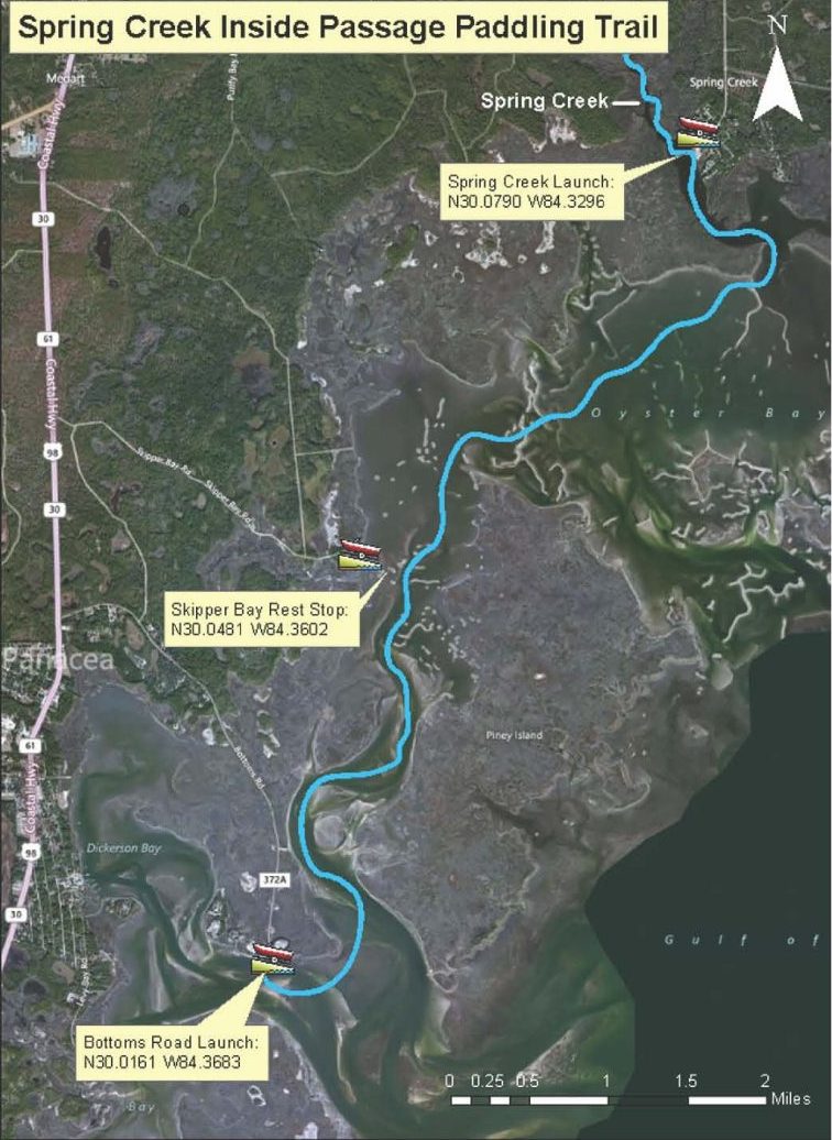
Overview: Begin at Bottoms Road Boat Ramp. Paddle north, along the shoreline of the St. Marks National Wildlife Refuge. Stop at Skipper Bay to rest or for a picnic. Continue into Oyster Bay toward the town of Spring Creek. Time permitting, paddle up Spring Creek and explore the upwelling springs around town. End at RV Park Boat Landing.
Considerations: Paddle near shore in shallow water. Watch for exposed oyster bars. Route is susceptible to wind and currents. Best traveled on an incoming high tide with little wind.
Focus: Photography and wildlife watching are reasons to take this trip.
Distance: 8 miles, 4 hours. It is 2.8 miles to the tip of island entering Spring Creek.
Put In: Take US 98 south past Medart. Before entering Panacea, turn left (east) onto Bottoms Road, indicated by a Byway and Great Florida Birding Trail sign with arrow. This dike road passes through Dickerson Bay in the Panacea Unit of the St. Marks National Wildlife Refuge. There is ample parking at the launch point at road’s end.
Take Out: Spring Creek boat landing adjacent to the RV Park. From Bottoms Road, take US Highway 98 north for 4.3 miles. Before the intersection with US Hwy 319 in Medart, turn right onto Jack Crum Drive for 3.7 miles to CR 365. Turn right on CR 365 for 2 miles to Spring Creek. Turn left into the RV Park at road’s end. Launch next to ramp, parking is available.
Expertise: Intermediate and up.
The following map and trail guide are provided courtesy of Florida Department of Environmental Protection, Florida Coastal Management Program, the Wakulla County Tourist Development Council and the Florida Department of Economic Opportunity.
Click here for trail map and guide.
DISCLAIMER: The Original Florida Tourism Task Force (dba Visit Natural North Florida) and the North Central Florida Regional Planning Council do not warrant the accuracy or timeliness of this map and paddle guide or the safety of this trail for use by paddlers. Paddlers should use this trail only if they have the adequate skill level and equipment, and paddlers must make that determination. Paddlers should also check weather forecasts and water levels in advance to avoid unnecessary danger. The Original Florida Tourism Task Force, the local governments in which this paddling trail is located and the North Central Florida Regional Planning Council are not responsible for any damages whatsoever from its use.