
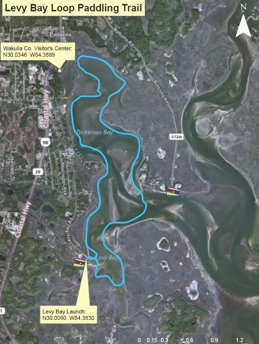
Levy Bay Loop
Levy Bay Boat Ramp, Levy Bay Road, Panacea, FL, USA
Add To Trip Planner Directions
Overview: Begin and end at the Levy Bay Boat Ramp. Follow the shoreline northward to the end of Dickerson Bay. Continue around the shore, following St. Marks National Wildlife Refuge property back into Levy Bay and boat ramp.
Considerations: This trip is in sheltered, shallow water. It is best enjoyed on a high tide.
Focus: Exploring Levy and Dickerson Bay adjacent to the St. Marks National Wildlife Refuge. Birding is excellent, especially in spring and fall.
Distance: 4.5 miles/ 2-3 hours.
Put In/ Take Out: Take US 98 south through Panacea. Turn right (east) onto Chattahoochee and left on Levy Bay Road. The boat ramp is at the end of the road, with restroom, trash cans, benches, and parking. Launch on sand next to asphalt ramp.
Expertise: Beginner and up.
The following map and trail guide are provided courtesy of Florida Department of Environmental Protection, Florida Coastal Management Program, the Wakulla County Tourist Development Council and the Florida Department of Economic Opportunity.
Click here for trail map and guide.
DISCLAIMER: The Original Florida Tourism Task Force (dba Visit Natural North Florida) and the North Central Florida Regional Planning Council do not warrant the accuracy or timeliness of this map and paddle guide or the safety of this trail for use by paddlers. Paddlers should use this trail only if they have the adequate skill level and equipment, and paddlers must make that determination. Paddlers should also check weather forecasts and water levels in advance to avoid unnecessary danger. The Original Florida Tourism Task Force, the local governments in which this paddling trail is located and the North Central Florida Regional Planning Council are not responsible for any damages whatsoever from its use.