
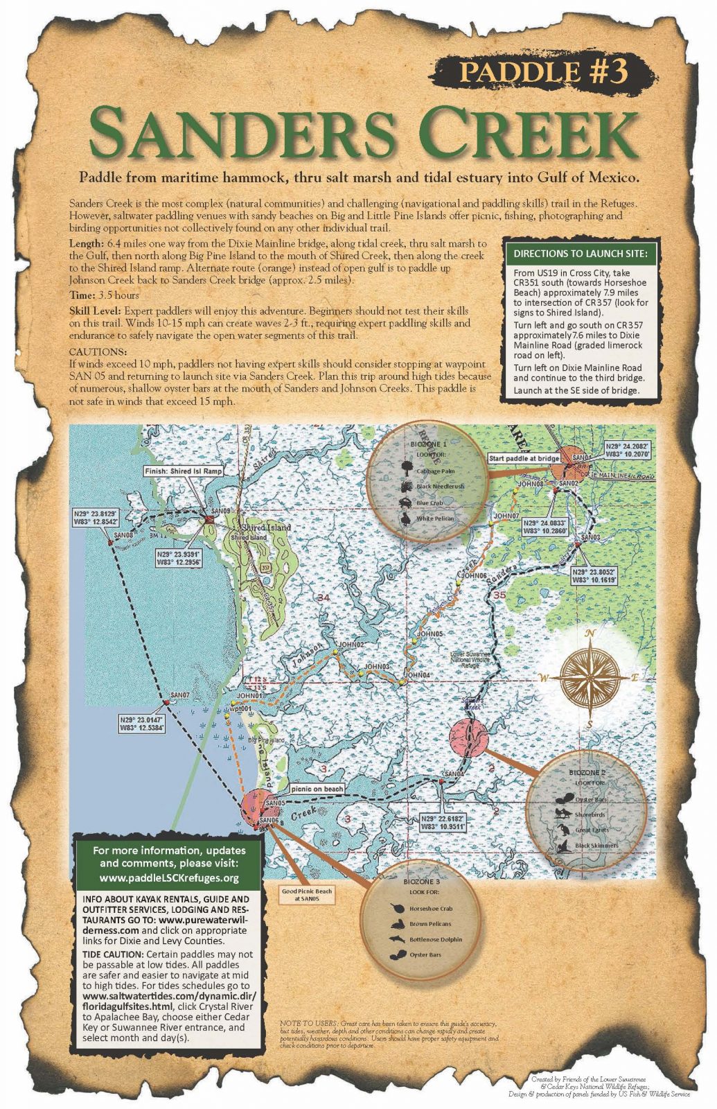
Sanders Creek
Sanders Creek, Florida, USA
http://www.friendsofrefuges.org/
Add To Trip Planner Directions
Paddle from maritime hammock, thru salt marsh and tidal estuary into Gulf of Mexico.
Sanders Creek is the most complex (natural communities) and challenging (navigational and paddling skills) trail in the Refuges. However, saltwater paddling venues with sandy beaches on Big and Little Pine Islands offer picnic, fishing, photographing and birding opportunities not collectively found on any other individual trail.
Length: 6.4 miles one way from the Dixie Mainline bridge, along tidal creek, thru salt marsh to the Gulf, then north along Big Pine Island to the mouth of Shired Creek, then along the creek to the Shired Island ramp. Alternate route (orange) instead of open gulf is to paddle up Johnson Creek back to Sanders Creek bridge (approx. 2.5 miles).
Time: 3.5 hours
Skill Level: Expert paddlers will enjoy this adventure. Beginners should not test their skills on this trail. Winds 10-15 mph can create waves 2-3 ft., requiring expert paddling skills and endurance to safely navigate the open water segments of this trail.
CAUTIONS: If winds exceed 10 mph, paddlers not having expert skills should consider stopping at waypoint SAN 05 and returning to launch site via Sanders Creek. Plan this trip around high tides because of numerous, shallow oyster bars at the mouth of Sanders and Johnson Creeks. This paddle is not safe in winds that exceed 15 mph.
The following map and trail guide are provided courtesy of Friends of the Lower Suwannee and Cedar Key National Wildlife Refuges.
Click here for trail map and guide.
Disclaimer: The Original Florida Tourism Task Force (dba VisitNatural Nroth Florida) and the North Central Florida Regional Planning Council do not warrant the accuracy or timeliness of this map and paddle guide or the safety of this trail for use by paddlers. Paddlers should use this trail only if they have the adequate skill level and dquipment, and paddlers must make that determination. Paddlers should also check weather forecases and wter levels in advance to avoid any unnecessary danger. The Original Florida Tourism Task Force, the local governments in which these paddling trails are located and the North Central Florida Regional Planning Council are not responsible for any damages whatsoever from its use.