Successful Fishing and Boating Depends on Your Understanding of Weather
This is NOT what you want to see if you’re headed to our Big Bend coastline to boat or fish!

A fun day on the Gulf or local rivers is very dependent on weather. And in Florida, in all seasons, it’s important to keep a “weather eye” peeled for weather approaching from the west. In summer and fall months, thunderstorms often build up over land and move shoreward, bringing deluges and lightning risks. In late winter and spring, strong fronts approach Florida’s Big Bend from the west on what is often a 3 or 4-day cycle–every cycle hitting hard, followed by nice clear weather in between.
What follows is a good primer on learning to predict weather from UCAR. (The University Corporation for Atmospheric Research is a consortium of more than 100 member colleges and universities focused on research and training in the atmospheric and related Earth system sciences.Members set directions and priorities for the National Center for Atmospheric Research, which UCAR manages with sponsorship by the National Science Foundation.)
|
|
|||||||||||||||
|
1. Study the weather maps The weather is constantly being measured all over the world. This data goes into weather maps that you can find on the Internet. These maps show cold and warm fronts, rainfall, cloudiness, and other information you need to make your forecast. Enter your zip code below to check the most recent forecast and weather maps for a city near you.
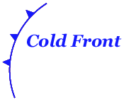
Review information about weather symbols shown below. Then study the online weather maps to see what can learn about current and predicted weather. Warm and Cold Fronts
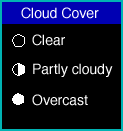
Cloud Cover Each circle represents a weather station. The circle at each station is empty if skies are clear. The circle is white if it’s cloudy. A line within the circle or a half-filled circle means “partly cloudy.”
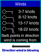
Wind and Wind Direction The little arrows attached to each weather station point in the direction the wind is blowing from. The more barbs at the end of each arrow, and the longer they are, the harder the wind is blowing. Each long barb is 10 knots (about 11.5 miles per hour or 18 kilometers per hour). Each short barb is half that amount. A barb that looks like a triangle is blowing at 50 knots (about 58 mph or 80 kph).
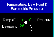
Air Temperature The number to the upper left of each station is the air temperature in degrees F (for U.S. maps) or degrees C (for other countries). Dew Point The number to the lower left of each station is the dew point temperature in degrees F (for U.S. maps) or degrees C (for other countries). The dew point is a measure of moisture; it shows how much you’d have to cool the air to get a relative humidity of 100 percent. The higher the dew point, the more water vapor there is for producing rain or snow. Barometric Pressure
The number to the upper right of each station is the barometric pressure. Since the pressure goes down with altitude, this reading has been adjusted to show the pressure as if the station were at sea level. The typical sea-level pressure is a little bit more than 1000 millibars. (The number is in kilopascals (kPa), which is the same as millibars). The number has been compressed to fit the map by lopping off the first one or two digits (which are always a “10” or a “9”) and omitting the decimal point before the last digit. For example, the code “085” would mean 1008.5 millibars, while 954 would be 995.4 millibars.
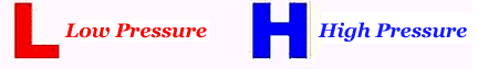
Put it all together! See if you can find any lines that go around centers of high and low pressure. They are called isobars; they connect stations with equal barometric pressure, so you can see where the highs and lows are. The wind usually follows the isobars, with a slight trend in the direction of the low pressure area. Look at the wind direction around your forecast city. Is the air blowing from colder areas toward your city, or is warmer air moving in?
Will clouds or precipitation be coming, and if so, a lot or a little? Will there be rain, sleet, or snow? 2. Study the satellite images Satellite images show the amount of cloud cover. Clouds can act like a blanket helping to keep night warmer if the sky is clear. But clouds during the daytime can block the sun and keep temperatures cooler. What does the image show? Is there much cloud cover? Do you think it will increase or decrease, based on what you have learned from the weather maps? 3. Study actual weather forecasts for your city In each country, the government issues an official forecast. However, you may see a different forecast in newspapers, television stations, and online services. These may not agree with each other. Do you think one of these services will be the most accurate every day, or will the truth be somewhere in between them? What will you do for your forecast if these sources do not agree? [Thunderstorms & Tornadoes] [Hurricanes] [Blizzards & Winter Weather] [Clouds] |
|||||||||||||||